


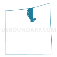
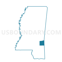
Hiwannee Voting District, Wayne County, Mississippi
About
Outline

Summary
| Unique Area Identifier | 606908 |
| Name | Hiwannee Voting District |
| County | Wayne County |
| State | Mississippi |
| Area (square miles) | 23.07 |
| Land Area (square miles) | 23.07 |
| Water Area (square miles) | 0.00 |
| % of Land Area | 100.00 |
| % of Water Area | 0.00 |
| Latitude of the Internal Point | 31.79006810 |
| Longtitude of the Internal Point | -88.66518590 |
Maps

Graphs
Select a template below for downloading or customizing gragh for Hiwannee Voting District, Wayne County, Mississippi


Neighbors
Neighoring Voting District (by Name) Neighboring Voting District on the Map
- Chaparral Voting District, Wayne County, MS
- Diamond Voting District, Wayne County, MS
- Langsdale Voting District, Clarke County, MS
- Shubuta Voting District, Clarke County, MS
- Waynesboro 3 Voting District, Wayne County, MS
- Yellow Creek Voting District, Wayne County, MS
Top 10 Neighboring County Subdivision (by Population) Neighboring County Subdivision on the Map
- District 2, Wayne County, MS (4,997)
- District 3, Wayne County, MS (3,744)
- District 2, Clarke County, MS (3,068)
- District 5, Clarke County, MS (2,517)
Top 10 Neighboring Unified School District (by Population) Neighboring Unified School District on the Map
Top 10 Neighboring State Legislative District Lower Chamber (by Population) Neighboring State Legislative District Lower Chamber on the Map
Top 10 Neighboring State Legislative District Upper Chamber (by Population) Neighboring State Legislative District Upper Chamber on the Map
Top 10 Neighboring 111th Congressional District (by Population) Neighboring 111th Congressional District on the Map
Top 10 Neighboring Census Tract (by Population) Neighboring Census Tract on the Map
- Census Tract 9501, Wayne County, MS (5,438)
- Census Tract 9503, Wayne County, MS (5,185)
- Census Tract 9501, Clarke County, MS (4,359)
- Census Tract 9503, Clarke County, MS (3,547)